

Critical Tools to lead you to the Right Solution for your Land

Published date:
March 01, 2018Last updated date:
March 01, 2018By Manny Manriquez
by Sonja Howle
Your Sunday Land News recently showcased some great options for generating side income from your small or large tract of commercial land.
We focus on the geographic tools, or Geographic Information Systems (GIS), to help make those decisions.
So as co-founder of Real Estate GIS, I couldn’t resist contacting Kevin May, LandHub.com’s President, to see if we could follow with more information.
As the land owner, your first considerations explore the “highest and best use,” which The Appraisal Institute defines as “the reasonably probable and legal use of vacant land or an improved property that is physically possible, appropriately supported, financially feasible, and that results in the highest value.”
Geographic information is essential in this space. Over the years we’ve identified 6 key maps to help determine distinctive attributes, natural resources, locational perspectives and other real and intrinsic assets and liabilities:
Location
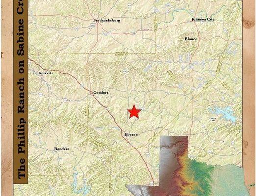
In cartography, this map shows the location of a particular geographic area within its larger and presumably more familiar context. “By analyzing data around locations, real estate professionals can target properties to match exact specifications and deliver the answers needed to make the most intelligent choices, so the use of GIS is a natural match for all aspects of real estate business.” Dr. Stephen McElroy, GIS program chair at American Sentinel UniversityAerial
This is the result of taking photographs from an airborne platform such as aircraft, helicopter, kite, blimp, drone, or unmanned aerial vehicle.Topographic
In modern mapping, a topographic map is a type of map characterized by large-scale detail and quantitative representation of relief, usually using contour lines, but historically using a variety of methods. Traditional definitions require a topographic map to show both natural and man-made features.Water/Wells
This map represents the excavations or structures in the ground from digging, driving, boring or drilling to access groundwater in underground aquifers. It may also represent aquifers, rivers and streams and the mineral levels in each.Soils
This is a representation showing diversity of soil types and/or soil properties (soil pH, textures, organic matter, depths of horizons, etc.) in the area of interest. It’s typically the end result of a soil survey inventory, i.e. soil survey.Flood Plain
Flood Plain maps show flood risk zones and their boundaries, and may also show floodways and Base Flood Elevations (BFEs). You can see examples of each from the link at the end of this post on the Real Estate GIS website. They can be a springboard for more questions and opportunities. They can lead you to more specific geographic information and data. These geographic tools are surprisingly underutilized. The geographic data available to you is generated by and utilized by federal, state and local agencies and municipalities. The cost is minimal when compared to the cost of investing in the wrong solution. At Real Estate GIS, we can guide you. We work with thought leaders in agriculture, energy and real estate as well as geographic information technology. Learn more or receive monthly case studies at RealEstateGIS.co, (https://www.realestategis.co/products/). Sonja Howle is a co-founder of RealEstateGIS.co, located outside San Antonio, Texas.All Land News
Leave a Reply
Land for Sale in the USA by State
- Alabama
- Alaska
- Arizona
- Arkansas
- California
- Colorado
- Connecticut
- Delaware
- Florida
- Georgia
- Hawaii
- Idaho
- Illinois
- Indiana
- Iowa
- Kansas
- Kentucky
- Louisiana
- Maine
- Maryland
- Massachusetts
- Michigan
- Minnesota
- Mississippi
- Missouri
- Montana
- Nebraska
- Nevada
- New Hampshire
- New Jersey
- New Mexico
- New York
- North Carolina
- North Dakota
- Ohio
- Oklahoma
- Oregon
- Pennsylvania
- Puerto Rico
- Rhode Island
- South Carolina
- South Dakota
- Tennessee
- Texas
- Utah
- Vermont
- Virginia
- Washington
- West Virginia
- Wisconsin
- Wyoming
Land for Sale in Costa Rica, Mexico & Canada
Property For Sale
Copyright ©️ 2024 by LandHub.com. LandHub ©️ is a registered trademark and cannot be used without permission.