


Scan with Smart
Phone Camera
Mono Lode At Brainard Lake
United States /Colorado, 1221 Brainard Lake Road, 80481, 4.64
For Sale
Listing ID :
13493124MLS ID :
390616Acres :
4.64 Acres$169,000
View Agent's Properties and Profile:

Hayden Outdoors
 Show Number
Show NumberHayden Outdoors Real Estate
Contact Seller
Property Description
There is not much private land left this close to the Divide, and less of it priced within reach. Nearly five acres at 9,600 feet on a timbered knoll below Brainard Lake, mostly level, wrapped by undeveloped municipal land, with paved road access year round. The Indian Peaks are up the road, and the country changes with every season. Use it now; build a cabin when you are ready. Five-parcel package.
Land
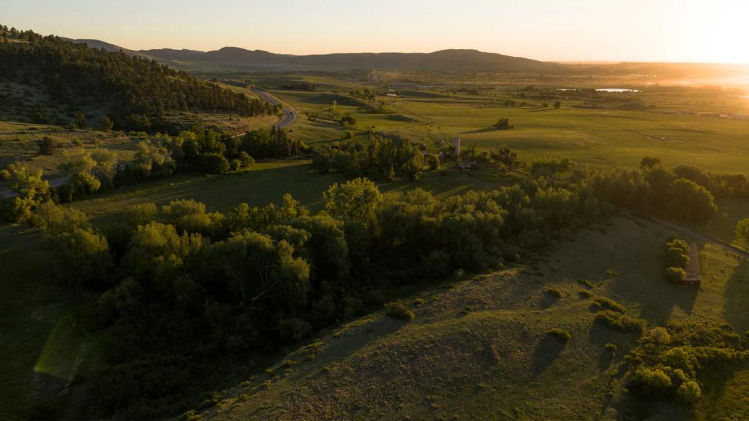
The parcel is the Mono Lode, Mineral Survey No. 11489, a patented mining claim in the Ward Mining District (Boulder County APN 145701000022). The ground rides a knoll under mature evergreen and aspen, high and mostly level, falling away on the east side to open views across the foothills. Undeveloped Town of Ward land wraps the property on multiple sides, and the surrounding ground is unimproved. This is among the last private land on Brainard Lake Road below the recreation area entrance. Off-grid parcel. Assessor acreage is 4.64; the patent and 1978 Treasurer’s Deed reflect 5.16 acres.
Additional parcels. Four additional parcels convey in a single transaction, all sold together as one package, adding approximately 2.41 acres for a total of roughly 7.05 acres across five parcels. Boulder County: 1424 Brainard Lake Road (APN 145701000026, 1.03 acres), a nearby claim in the Ward Mining District lying west of Mono Lode, closer still to the recreation area; and a parcel on Indiana Gulch Road (APN 145907000020, 1.21 acres) east of Ward. Gilpin County: two adjoining lots in the South Pine Cliff subdivision, Block 4, Lots 19 and 20 (APNs 158127400078 and 158127400153, 0.17 acres combined). These convey by quitclaim deed at closing and are held in the same ownership. They are offered as additional holdings; access varies among them and is not established on all. Additional detail available upon inquiry.
Improvements
The property is unimproved. A Boulder County Building Lot Determination has been issued, and the parcel carries 1,000 square feet of residential floor area under county regulation. The ground lends itself to a cabin, a small mountain retreat, or an off-grid basecamp.
Access is physical and established. A gate and maintained dirt road turn south off paved Brainard Lake Road (County Road 102) and reach the property, serving neighboring holdings as well, and have for many years.
Recreation
Brainard Lake Recreation Area begins minutes up the road, and the Indian Peaks Wilderness begins just past it. Five glacial lakes, classic ski descents of the northern Front Range, alpine rock on the Divide, native cutthroat above treeline, and a birding list that runs from spruce-fir to tundra, all inside a few miles of the property. Most of it draws day-trippers from the cities below. This property sits below the gate, on the year-round side, close enough that the whole drainage functions as an extension of the parcel and immediate enough to serve as a basecamp for all of it.
Summer. Hiking is the reason most people come. The Long Lake and Mitchell Lake trailheads open onto the best-known alpine terrain in this part of the state. Long Lake is a third of a mile from the trailhead with a flat two-mile loop around it, easy enough for anyone. Two miles and five hundred feet further, the Pawnee Pass Trail reaches Lake Isabelle, framed by Apache, Shoshoni, and Navajo. Beyond it the route climbs another two miles and fourteen hundred feet to the remnant Isabelle Glacier, or turns north and switchbacks to Pawnee Pass at 12,541 feet, where the trail crosses the Divide. From the Mitchell Lake side, a short walk through subalpine woods and over Mitchell Creek reaches Mitchell Lake under Mount Audubon, with Blue Lake above it at treeline. Mount Audubon, at 13,223 feet, is the classic summit of the group and the one most parties climb first. The Beaver Creek and Coney Lakes trails run north from there into quieter country. Wildflowers peak in July, and the meadows below Pawnee Pass are among the best displays in the range.
Fishing. Brainard Lake sits at 10,340 feet at the end of the road and holds brook, brown, and cutthroat trout; non-motorized boating is permitted, and Red Rock Lake lies a mile and a half east in the same recreation area. Short trails climb from there to Long Lake at 10,525 feet, Mitchell Lake at 10,715, and Lake Isabelle at 10,899, all with brook, rainbow, and native cutthroat. Blue Lake, the highest and deepest of the group at 11,340 feet and well above treeline, is the one anglers walk in for; its depth supports greenback cutthroat, and fishing runs best from ice-out in late June through July. The connecting water fishes too. South St. Vrain Creek crosses the Long Lake trail on footbridges, and Mitchell Creek below gives up brook trout through the season. Beyond the immediate drainage, the Indian Peaks Wilderness holds dozens of lakes between 10,000 and 12,000 feet. Lower down, three branches of the St. Vrain run within a short drive, with rainbow and brown and easy access from the road.
Wildlife and birding. Brainard Lake is a listed site on the Colorado Birding Trail and one of Boulder County Audubon’s local destinations, and the draw is habitat stacked in a short distance. The spruce-fir forest around the lake holds Canada Jays, American Three-toed Woodpeckers, and Dusky Grouse, with Boreal Owls occasionally reported at night in winter. The willow thickets at the lower end of Long Lake support nesting American Dipper, Swainson’s Thrush, and Wilson’s Warbler, along with Lincoln’s, White-crowned, and Fox Sparrows; Ring-necked Ducks and Spotted Sandpipers nest around the water. The old-growth on Niwot Ridge holds Clark’s Nutcrackers, kinglets, Townsend’s Solitaires, and Pine Grosbeaks. Above treeline, White-tailed Ptarmigan, American Pipits, and Brown-capped Rosy-Finch nest on the tundra; the rosy-finch is a Colorado near-endemic and one of the reasons birders make the climb. Elk, mule deer, bighorn sheep, and pika are all in this country, and moose increasingly call the drainage home.
Cycling. Brainard Lake Road is a destination climb in its own right, and it runs past the property. The ride from Nederland through Ward to the lake gains roughly 2,200 feet, topping out at 10,500. Below Ward, Left Hand Canyon is one of the most popular bike climbs in the Boulder area, roughly seventeen miles and 3,700 feet at a steady grade, with the hardest mile and a half just before town. The Peak to Peak Highway runs north and south from there with wide shoulders through most of its length, and the Boulder to Lyons to Raymond to Ward loop is a classic at about sixty-seven miles and 5,600 feet. The dirt riding is just as deep. Mountain bikes are allowed on the CMC, Waldrop, South Saint Vrain, and Sourdough trails and on Left Hand Park Reservoir Road, with Sawmill Road above Ward another well-used option. Ceran St. Vrain to Miller Rock rides year round just south of town. Buchanan Pass Trail at Camp Dick, six miles north, is open to bikes for its first five miles. Twenty minutes south, the West Magnolia network outside Nederland holds a maze of singletrack, a thirteen-mile intermediate loop, and groomed fat-bike trails in winter.
Climbing and mountaineering. Mount Toll, the rock pyramid that anchors the Blue Lakes drainage, holds alpine rock routes on its north ridge and northeast face along with a mixed couloir on its north side. The cliff above Blue Lake is known as approachable alpine rock with a walk-off descent. Ridge traverses link Little Pawnee, Pawnee, and Toll over three summits and four lakes. Apache, Navajo, and Shoshoni carry harder lines further west along the Divide. Lone Eagle Peak, the granite spire above Crater Lake and one of the most striking summits in the state, is reached from the west at Monarch Lake or from this side over Pawnee Pass; the Stettner route on its north face is a classic, and the eastern approach out of Long Lake is the one Front Range parties take. Closer in, Camp Dick holds alpine bouldering on big blocks scattered up the Middle St. Vrain valley, six miles north and written up in the Colorado guidebooks.
Backcountry skiing. This is what the area is known for among those who go in winter and spring. The southeast face of Mount Toll is the classic descent of the Indian Peaks, a summit ski down a wide open face. Audubon carries excellent lines on three sides, including the Crooked Couloir down to Blue Lake. Pawnee’s southeast face holds some of the best moderate terrain in the range plus one of the finest couloirs reached from Brainard. The Apache Couloir is another of the classic descents. Paiute is considered under-skied because Toll and Audubon take the attention.
Winter access. From mid-October to mid-June the gate above closes and the area becomes a backcountry destination reached on foot, skis, or snowshoes from the Gateway Trailhead, which stays open and plowed year round. On spring weekends that lot fills before dawn with skiers who have driven up from the cities. The parcel sits minutes below it. Nordic and touring trails run through the drainage, including the Colorado Mountain Club’s own ski trails and its Brainard cabin, and the area has a long cross-country history.
Hunting. Brainard Lake Road forms the boundary between Game Management Units 20 and 29. Unit 29 lies south of it; Unit 20 begins on the north side and runs to the Rocky Mountain National Park line. A basecamp here puts a hunter in either without relocating, and both are largely Roosevelt National Forest, which runs to more than 800,000 acres of public ground. Unit 20 borders the park’s unhunted elk herd, and Parks and Wildlife has added December and January bull seasons in that unit alone to follow the migration out of it. Tag numbers are small and pressure is correspondingly light; elk and deer are both draw. Unit 29 covers the mountain country west of Boulder and is spot-and-stalk terrain that tends to reward the hunters willing to walk. Elk, mule deer, and black bear are all present. The practical advantage is the road. A December or January tag means winter access, and this parcel is on pavement that gets plowed while the two-tracks in both units are closed and gated.
Water/Mineral Rights & Natural Resources
Seller conveys whatever mineral interest it holds without representation or warranty. Buyers for whom mineral ownership is material should confirm independently through their own counsel.
Region & Climate
The property sits at 9,600 feet on the eastern flank of the Continental Divide, in subalpine forest of evergreen and aspen. It lies on Brainard Lake Road west of Ward, in the high country above Left Hand Canyon. Summers are cool and short. July highs average in the mid-70s, roughly fifteen degrees below Denver, and nights hold in the 40s through August. Wildflowers peak in July. Winter brings a long season and heavy snow; the area averages more than seven feet a year, and snow falls in every month but July. Brainard Lake Road is county-maintained and plowed through the winter, and the stretch below the recreation area gate stays open year round. Winter driving at this elevation warrants appropriate tires and traction. Ward is immediately east on the Peak to Peak Highway, a former mining town of roughly 130 residents. Nederland, with groceries, fuel, and restaurants, is about twenty minutes south. Boulder is roughly forty minutes down the canyon, and Denver about ninety.
History
The Ward Mining District opened in 1861, when Calvin Ward found gold just east of Indiana Gulch on the hillside north of Lefthand Creek. The Columbia vein followed a year later, and the town of Ward grew up around it. By 1865 roughly 600 people were working the district. The Switzerland Trail railroad reached Ward in 1898, a narrow gauge line running thirty miles through the mountains to carry ore down to the plains. It shut down in 1919, and the Peak to Peak Highway brought the area back in the 1930s as something quieter.
The Mono Lode dates to that era. The federal patent issued to Arnold Alexander on December 4, 1897, following an 1891 quitclaim in the chain. The adjoining Johanna claim was patented in 1899 and expressly excluded the area of overlap, confirming the Mono Lode as the senior claim. The seller’s family acquired the property in 1971, and it has not been offered for sale since.
Brainard Lake up the road takes its name from Colonel Wesley Brainerd, who ran the Chicago and Colorado Mining Company’s operations in the Ward District. The reservoir traces to an 1895 placer claim on the St. Vrain, and county maps still labeled it Brainerd’s Lake into the 1920s. Brainard Lake became public land in 1949, transferred to the National Forest in a swap with the mining and reservoir company that had held the reservoir claim. People had been going up there long before that; the Civilian Conservation Corps built recreational improvements in the valley during the Depression.
Please note. Legal access of record has not been established and the title commitment will except access. Buyer to verify access, utility availability, well permitting, buildability, and onsite wastewater feasibility with the county, the serving utility, and independent counsel. The Building Lot Determination, title work, and survey documentation are available for review. Boulder County Land Use Code Article 4-507.B.5.c permits camping on a parcel 14 days per year. Recreational vehicles are not dwellings under Article 18-137 and may not be occupied as such on vacant land. Buyers should confirm current requirements with the county. Listed acreage of 4.64 is the assessor’s figure for 1221 Brainard Lake Road only. Estimated taxes of $235.92 per year cover all five parcels.
Land
The parcel is the Mono Lode, Mineral Survey No. 11489, a patented mining claim in the Ward Mining District (Boulder County APN 145701000022). The ground rides a knoll under mature evergreen and aspen, high and mostly level, falling away on the east side to open views across the foothills. Undeveloped Town of Ward land wraps the property on multiple sides, and the surrounding ground is unimproved. This is among the last private land on Brainard Lake Road below the recreation area entrance. Off-grid parcel. Assessor acreage is 4.64; the patent and 1978 Treasurer’s Deed reflect 5.16 acres.
Additional parcels. Four additional parcels convey in a single transaction, all sold together as one package, adding approximately 2.41 acres for a total of roughly 7.05 acres across five parcels. Boulder County: 1424 Brainard Lake Road (APN 145701000026, 1.03 acres), a nearby claim in the Ward Mining District lying west of Mono Lode, closer still to the recreation area; and a parcel on Indiana Gulch Road (APN 145907000020, 1.21 acres) east of Ward. Gilpin County: two adjoining lots in the South Pine Cliff subdivision, Block 4, Lots 19 and 20 (APNs 158127400078 and 158127400153, 0.17 acres combined). These convey by quitclaim deed at closing and are held in the same ownership. They are offered as additional holdings; access varies among them and is not established on all. Additional detail available upon inquiry.
Improvements
The property is unimproved. A Boulder County Building Lot Determination has been issued, and the parcel carries 1,000 square feet of residential floor area under county regulation. The ground lends itself to a cabin, a small mountain retreat, or an off-grid basecamp.
Access is physical and established. A gate and maintained dirt road turn south off paved Brainard Lake Road (County Road 102) and reach the property, serving neighboring holdings as well, and have for many years.
Recreation
Brainard Lake Recreation Area begins minutes up the road, and the Indian Peaks Wilderness begins just past it. Five glacial lakes, classic ski descents of the northern Front Range, alpine rock on the Divide, native cutthroat above treeline, and a birding list that runs from spruce-fir to tundra, all inside a few miles of the property. Most of it draws day-trippers from the cities below. This property sits below the gate, on the year-round side, close enough that the whole drainage functions as an extension of the parcel and immediate enough to serve as a basecamp for all of it.
Summer. Hiking is the reason most people come. The Long Lake and Mitchell Lake trailheads open onto the best-known alpine terrain in this part of the state. Long Lake is a third of a mile from the trailhead with a flat two-mile loop around it, easy enough for anyone. Two miles and five hundred feet further, the Pawnee Pass Trail reaches Lake Isabelle, framed by Apache, Shoshoni, and Navajo. Beyond it the route climbs another two miles and fourteen hundred feet to the remnant Isabelle Glacier, or turns north and switchbacks to Pawnee Pass at 12,541 feet, where the trail crosses the Divide. From the Mitchell Lake side, a short walk through subalpine woods and over Mitchell Creek reaches Mitchell Lake under Mount Audubon, with Blue Lake above it at treeline. Mount Audubon, at 13,223 feet, is the classic summit of the group and the one most parties climb first. The Beaver Creek and Coney Lakes trails run north from there into quieter country. Wildflowers peak in July, and the meadows below Pawnee Pass are among the best displays in the range.
Fishing. Brainard Lake sits at 10,340 feet at the end of the road and holds brook, brown, and cutthroat trout; non-motorized boating is permitted, and Red Rock Lake lies a mile and a half east in the same recreation area. Short trails climb from there to Long Lake at 10,525 feet, Mitchell Lake at 10,715, and Lake Isabelle at 10,899, all with brook, rainbow, and native cutthroat. Blue Lake, the highest and deepest of the group at 11,340 feet and well above treeline, is the one anglers walk in for; its depth supports greenback cutthroat, and fishing runs best from ice-out in late June through July. The connecting water fishes too. South St. Vrain Creek crosses the Long Lake trail on footbridges, and Mitchell Creek below gives up brook trout through the season. Beyond the immediate drainage, the Indian Peaks Wilderness holds dozens of lakes between 10,000 and 12,000 feet. Lower down, three branches of the St. Vrain run within a short drive, with rainbow and brown and easy access from the road.
Wildlife and birding. Brainard Lake is a listed site on the Colorado Birding Trail and one of Boulder County Audubon’s local destinations, and the draw is habitat stacked in a short distance. The spruce-fir forest around the lake holds Canada Jays, American Three-toed Woodpeckers, and Dusky Grouse, with Boreal Owls occasionally reported at night in winter. The willow thickets at the lower end of Long Lake support nesting American Dipper, Swainson’s Thrush, and Wilson’s Warbler, along with Lincoln’s, White-crowned, and Fox Sparrows; Ring-necked Ducks and Spotted Sandpipers nest around the water. The old-growth on Niwot Ridge holds Clark’s Nutcrackers, kinglets, Townsend’s Solitaires, and Pine Grosbeaks. Above treeline, White-tailed Ptarmigan, American Pipits, and Brown-capped Rosy-Finch nest on the tundra; the rosy-finch is a Colorado near-endemic and one of the reasons birders make the climb. Elk, mule deer, bighorn sheep, and pika are all in this country, and moose increasingly call the drainage home.
Cycling. Brainard Lake Road is a destination climb in its own right, and it runs past the property. The ride from Nederland through Ward to the lake gains roughly 2,200 feet, topping out at 10,500. Below Ward, Left Hand Canyon is one of the most popular bike climbs in the Boulder area, roughly seventeen miles and 3,700 feet at a steady grade, with the hardest mile and a half just before town. The Peak to Peak Highway runs north and south from there with wide shoulders through most of its length, and the Boulder to Lyons to Raymond to Ward loop is a classic at about sixty-seven miles and 5,600 feet. The dirt riding is just as deep. Mountain bikes are allowed on the CMC, Waldrop, South Saint Vrain, and Sourdough trails and on Left Hand Park Reservoir Road, with Sawmill Road above Ward another well-used option. Ceran St. Vrain to Miller Rock rides year round just south of town. Buchanan Pass Trail at Camp Dick, six miles north, is open to bikes for its first five miles. Twenty minutes south, the West Magnolia network outside Nederland holds a maze of singletrack, a thirteen-mile intermediate loop, and groomed fat-bike trails in winter.
Climbing and mountaineering. Mount Toll, the rock pyramid that anchors the Blue Lakes drainage, holds alpine rock routes on its north ridge and northeast face along with a mixed couloir on its north side. The cliff above Blue Lake is known as approachable alpine rock with a walk-off descent. Ridge traverses link Little Pawnee, Pawnee, and Toll over three summits and four lakes. Apache, Navajo, and Shoshoni carry harder lines further west along the Divide. Lone Eagle Peak, the granite spire above Crater Lake and one of the most striking summits in the state, is reached from the west at Monarch Lake or from this side over Pawnee Pass; the Stettner route on its north face is a classic, and the eastern approach out of Long Lake is the one Front Range parties take. Closer in, Camp Dick holds alpine bouldering on big blocks scattered up the Middle St. Vrain valley, six miles north and written up in the Colorado guidebooks.
Backcountry skiing. This is what the area is known for among those who go in winter and spring. The southeast face of Mount Toll is the classic descent of the Indian Peaks, a summit ski down a wide open face. Audubon carries excellent lines on three sides, including the Crooked Couloir down to Blue Lake. Pawnee’s southeast face holds some of the best moderate terrain in the range plus one of the finest couloirs reached from Brainard. The Apache Couloir is another of the classic descents. Paiute is considered under-skied because Toll and Audubon take the attention.
Winter access. From mid-October to mid-June the gate above closes and the area becomes a backcountry destination reached on foot, skis, or snowshoes from the Gateway Trailhead, which stays open and plowed year round. On spring weekends that lot fills before dawn with skiers who have driven up from the cities. The parcel sits minutes below it. Nordic and touring trails run through the drainage, including the Colorado Mountain Club’s own ski trails and its Brainard cabin, and the area has a long cross-country history.
Hunting. Brainard Lake Road forms the boundary between Game Management Units 20 and 29. Unit 29 lies south of it; Unit 20 begins on the north side and runs to the Rocky Mountain National Park line. A basecamp here puts a hunter in either without relocating, and both are largely Roosevelt National Forest, which runs to more than 800,000 acres of public ground. Unit 20 borders the park’s unhunted elk herd, and Parks and Wildlife has added December and January bull seasons in that unit alone to follow the migration out of it. Tag numbers are small and pressure is correspondingly light; elk and deer are both draw. Unit 29 covers the mountain country west of Boulder and is spot-and-stalk terrain that tends to reward the hunters willing to walk. Elk, mule deer, and black bear are all present. The practical advantage is the road. A December or January tag means winter access, and this parcel is on pavement that gets plowed while the two-tracks in both units are closed and gated.
Water/Mineral Rights & Natural Resources
Seller conveys whatever mineral interest it holds without representation or warranty. Buyers for whom mineral ownership is material should confirm independently through their own counsel.
Region & Climate
The property sits at 9,600 feet on the eastern flank of the Continental Divide, in subalpine forest of evergreen and aspen. It lies on Brainard Lake Road west of Ward, in the high country above Left Hand Canyon. Summers are cool and short. July highs average in the mid-70s, roughly fifteen degrees below Denver, and nights hold in the 40s through August. Wildflowers peak in July. Winter brings a long season and heavy snow; the area averages more than seven feet a year, and snow falls in every month but July. Brainard Lake Road is county-maintained and plowed through the winter, and the stretch below the recreation area gate stays open year round. Winter driving at this elevation warrants appropriate tires and traction. Ward is immediately east on the Peak to Peak Highway, a former mining town of roughly 130 residents. Nederland, with groceries, fuel, and restaurants, is about twenty minutes south. Boulder is roughly forty minutes down the canyon, and Denver about ninety.
History
The Ward Mining District opened in 1861, when Calvin Ward found gold just east of Indiana Gulch on the hillside north of Lefthand Creek. The Columbia vein followed a year later, and the town of Ward grew up around it. By 1865 roughly 600 people were working the district. The Switzerland Trail railroad reached Ward in 1898, a narrow gauge line running thirty miles through the mountains to carry ore down to the plains. It shut down in 1919, and the Peak to Peak Highway brought the area back in the 1930s as something quieter.
The Mono Lode dates to that era. The federal patent issued to Arnold Alexander on December 4, 1897, following an 1891 quitclaim in the chain. The adjoining Johanna claim was patented in 1899 and expressly excluded the area of overlap, confirming the Mono Lode as the senior claim. The seller’s family acquired the property in 1971, and it has not been offered for sale since.
Brainard Lake up the road takes its name from Colonel Wesley Brainerd, who ran the Chicago and Colorado Mining Company’s operations in the Ward District. The reservoir traces to an 1895 placer claim on the St. Vrain, and county maps still labeled it Brainerd’s Lake into the 1920s. Brainard Lake became public land in 1949, transferred to the National Forest in a swap with the mining and reservoir company that had held the reservoir claim. People had been going up there long before that; the Civilian Conservation Corps built recreational improvements in the valley during the Depression.
Please note. Legal access of record has not been established and the title commitment will except access. Buyer to verify access, utility availability, well permitting, buildability, and onsite wastewater feasibility with the county, the serving utility, and independent counsel. The Building Lot Determination, title work, and survey documentation are available for review. Boulder County Land Use Code Article 4-507.B.5.c permits camping on a parcel 14 days per year. Recreational vehicles are not dwellings under Article 18-137 and may not be occupied as such on vacant land. Buyers should confirm current requirements with the county. Listed acreage of 4.64 is the assessor’s figure for 1221 Brainard Lake Road only. Estimated taxes of $235.92 per year cover all five parcels.

Basic Details
Listing Type:
For SaleListing ID:
13493124Price:
$169,000Acres:
4.64 AcresAddress Map
Country:
United StatesState:
ColoradoCounty:
BoulderCity:
WardLatitude:
40.077676217Longitude:
-105.51297038Street Address:
1221 Brainard Lake RoadSimilar Listings



Land for Sale in the USA by State
- Alabama
- Alaska
- Arizona
- Arkansas
- California
- Colorado
- Connecticut
- Delaware
- Florida
- Georgia
- Hawaii
- Idaho
- Illinois
- Indiana
- Iowa
- Kansas
- Kentucky
- Louisiana
- Maine
- Maryland
- Massachusetts
- Michigan
- Minnesota
- Mississippi
- Missouri
- Montana
- Nebraska
- Nevada
- New Hampshire
- New Jersey
- New Mexico
- New York
- North Carolina
- North Dakota
- Ohio
- Oklahoma
- Oregon
- Pennsylvania
- Puerto Rico
- Rhode Island
- South Carolina
- South Dakota
- Tennessee
- Texas
- Utah
- Vermont
- Virginia
- Washington
- West Virginia
- Wisconsin
- Wyoming
Land for Sale in Costa Rica, Mexico & Canada
Property For Sale


Copyright ©️ 2026 by LandHub.com. LandHub ©️ is a registered trademark and cannot be used without permission.