Scan with Smart
Phone Camera
Mona Meadows
United States /Wyoming, 3159 Mona Road, 82710, 21.47
For Sale
Listing ID :
66092831MLS ID :
447913Acres :
21.47 Acres$129,000
View Agent's Properties and Profile:

Hayden Outdoors
 Show Number
Show NumberHayden Outdoors Real Estate
Contact Seller
Property Description
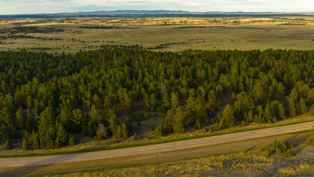
21.47 acres of meadow and Ponderosa pine and oak timber on Mona Road (CR 222) in Crook County, Wyoming, on the northern edge of the Black Hills. Rolling terrain, open meadow, and a seasonal creek in the southwest corner. Electric at the east boundary, a shared well across the road, and county road access. Perimeter-fenced as part of an available combined 40.76-acre holding. This is the perfect recreational retreat, hunting camp, or homesite.
Land
The parcel is irregularly shaped and roughly triangular, with Mona Road (CR 222) forming the southern boundary and Majestic View Road bordering the eastern boundary. Elevation ranges from 3,448.7 feet at the lower western edge to 3,528.8 feet on the higher northeastern ground, a total relief of approximately 80 feet. Average slope across the parcel is 7.8%, with localized steeper pitches reaching 31.4% in the upper northeastern corner. A seasonal creek occupies the southwest corner, corresponding generally to the FEMA-mapped 100-year floodplain along the western and southern boundary. The creek corridor and associated floodplain affect an estimated 3 to 5 acres. Buildable area on the higher eastern ground is unencumbered by flood hazard and benefits from proximity to the electric service at the east boundary.
Improvements
No permanent structures are present on the parcel. Electric service is available at the east boundary, eliminating one of the primary infrastructure cost items associated with Black Hills vacant land development. A shared well for development purposes is located across the road from the east property line, providing accessible domestic water without the need for an on-site well permit or drilling program. Private engineered septic will still be required. Perimeter fencing runs around the exterior boundary of the combined 40.76-acre holding encompassing this parcel and the adjacent Majestic View Road tract; the interior boundary between the two parcels is not separately fenced. No corrals, outbuildings, or paved surfaces are present.
Recreation
The seasonal creek in the southwest corner is the parcel’s signature recreational feature, delivering a genuine water element to a class of bare land that seldom offers one. Its drainage corridor is a natural travel and watering route, concentrating wildlife movement along a defined edge and giving the property a built-in focal point for a camp, a glassing knob, or a quiet morning of wildlife observation. Water on the land changes how a parcel hunts and how it lives, and this corner is where the property comes alive.
The broader ground reads like designed habitat. Open meadow provides feeding and green-up in the shoulder seasons, dense Ponderosa pine and oak pockets give bedding, thermal cover, and mast, and the meadow-to-timber edges are the transition zones where game holds and moves. That structure supports resident whitetail deer, mule deer, and wild turkey, and elk are a realistic possibility given the parcel’s proximity to the Black Hills National Forest and the herds that range the Bear Lodge Mountains. Hunting opportunity is subject to Wyoming Game and Fish Department seasons and licensing.
Beyond the hunt, the property carries a full recreational calendar. Spring brings turkey and shed antlers along the timber lines, summer opens the meadows to hiking, camping, and dark-sky stargazing well away from town light, fall is the deer and elk woods, and winter offers tracking, quiet, and solitude. The blend of meadow openings, timber, water, and ready utility access gives this tract a recreation and homesite profile that outperforms most competing listings in the Crook County corridor.
The location extends that appeal. Devils Tower National Monument, the Bearlodge Ranger District of the Black Hills National Forest, and the wider trail, camping, and public-land network of the northern Wyoming Black Hills are all within a short drive, turning 21.47 private acres into a base camp for a region’s worth of country.
Water/Mineral Rights & Natural Resources
A seasonal creek occupies the southwest corner of the parcel. The seller reports the creek was flowing consistently during visits to the property; it is classified as seasonal by county and FEMA mapping. The creek corridor corresponds to the FEMA-mapped 100-year floodplain along the western boundary. A shared well available for development is located across the road from the east property line. Terms of the shared-well agreement, water rights, and any associated use or maintenance obligations should be confirmed during due diligence. No adjudicated surface water rights are documented on this property. Standing Ponderosa pine and oak timber is present throughout the central and northern portions of the parcel; no merchantable timber cruise has been conducted. Mineral rights ownership is unknown and should be verified through a title commitment prior to closing.
Region & Climate
Crook County anchors the northeastern corner of Wyoming, sharing its eastern boundary with South Dakota and its northern boundary with Montana. This is where two landscapes meet: the open grass-and-sage high plains rolling up from the east and south, and the timbered, uplifted country of the Black Hills and the Bear Lodge Mountains rising to the west. The Aladdin area sits squarely on that northern fringe of the Black Hills, a transitional zone of rolling, pine-studded hills, hay meadows, and live-water draws that has drawn ranchers, timber families, and recreationists for generations. It is quiet, uncrowded ranch country, with the services of Sundance and the northern Hills a manageable drive away.
The climate is semi-arid continental, giving the area four clearly defined seasons. Winters are cold and generally dry, summers are warm and comfortable with low humidity and cool evenings at elevation, and the shoulder seasons are long and scenic. Annual precipitation averages roughly 15 to 20 inches, most of it arriving as spring and early-summer rain that greens the meadows and feeds the seasonal draws. Snow is possible from October into April, though open winters are common, and the dry, mild summers are well suited to building, camping, and outdoor recreation.
The ownership climate is as favorable as the weather. Wyoming levies no state personal income tax, and Crook County’s property taxes rank among the lowest in the region, with annual taxes on this parcel estimated at $714. Landmarks are close at hand: Devils Tower National Monument lies roughly 35 miles by road to the west via Wyoming Highway 24, and the trails, forests, and lakes of the northern Black Hills are within an easy drive.
History
Crook County takes its name from General George Crook, who conducted military campaigns through northeastern Wyoming during the 1876 Great Sioux War. The discovery of gold during General Custer’s 1874 expedition triggered a rush of settlement that reshaped the region within a generation. Northeastern Wyoming was homesteaded in the late 19th century as cattlemen and small farmers pushed into the grasslands and timber foothills surrounding the Black Hills. The community of Aladdin, established in the 1880s, remains one of the most distinctive rural outposts in Wyoming. Aladdin’s general store, in continuous operation since 1896, is recognized as one of the oldest operating general stores in the state and serves as a community gathering point for ranchers and visitors alike.
Location
The property is accessed via Mona Road (CR 222), a county-maintained gravel road providing year-round access. Aladdin, Wyoming is approximately 7 to 9 miles to the south, offering minimal local services. Sundance, Wyoming, the Crook County seat, is approximately 30 miles south via Wyoming Highway 111 and provides basic retail, fuel, medical, and county government services. Belle Fourche, South Dakota is approximately 25 to 30 miles east. Spearfish, South Dakota is approximately 40 miles southeast, offering expanded retail, dining, and medical options. Rapid City, South Dakota is approximately 90 miles southeast and provides regional airport access, major medical facilities, and full commercial services. Devils Tower National Monument is approximately 35 miles west via Wyoming Highway 24.
Land
The parcel is irregularly shaped and roughly triangular, with Mona Road (CR 222) forming the southern boundary and Majestic View Road bordering the eastern boundary. Elevation ranges from 3,448.7 feet at the lower western edge to 3,528.8 feet on the higher northeastern ground, a total relief of approximately 80 feet. Average slope across the parcel is 7.8%, with localized steeper pitches reaching 31.4% in the upper northeastern corner. A seasonal creek occupies the southwest corner, corresponding generally to the FEMA-mapped 100-year floodplain along the western and southern boundary. The creek corridor and associated floodplain affect an estimated 3 to 5 acres. Buildable area on the higher eastern ground is unencumbered by flood hazard and benefits from proximity to the electric service at the east boundary.
Improvements
No permanent structures are present on the parcel. Electric service is available at the east boundary, eliminating one of the primary infrastructure cost items associated with Black Hills vacant land development. A shared well for development purposes is located across the road from the east property line, providing accessible domestic water without the need for an on-site well permit or drilling program. Private engineered septic will still be required. Perimeter fencing runs around the exterior boundary of the combined 40.76-acre holding encompassing this parcel and the adjacent Majestic View Road tract; the interior boundary between the two parcels is not separately fenced. No corrals, outbuildings, or paved surfaces are present.
Recreation
The seasonal creek in the southwest corner is the parcel’s signature recreational feature, delivering a genuine water element to a class of bare land that seldom offers one. Its drainage corridor is a natural travel and watering route, concentrating wildlife movement along a defined edge and giving the property a built-in focal point for a camp, a glassing knob, or a quiet morning of wildlife observation. Water on the land changes how a parcel hunts and how it lives, and this corner is where the property comes alive.
The broader ground reads like designed habitat. Open meadow provides feeding and green-up in the shoulder seasons, dense Ponderosa pine and oak pockets give bedding, thermal cover, and mast, and the meadow-to-timber edges are the transition zones where game holds and moves. That structure supports resident whitetail deer, mule deer, and wild turkey, and elk are a realistic possibility given the parcel’s proximity to the Black Hills National Forest and the herds that range the Bear Lodge Mountains. Hunting opportunity is subject to Wyoming Game and Fish Department seasons and licensing.
Beyond the hunt, the property carries a full recreational calendar. Spring brings turkey and shed antlers along the timber lines, summer opens the meadows to hiking, camping, and dark-sky stargazing well away from town light, fall is the deer and elk woods, and winter offers tracking, quiet, and solitude. The blend of meadow openings, timber, water, and ready utility access gives this tract a recreation and homesite profile that outperforms most competing listings in the Crook County corridor.
The location extends that appeal. Devils Tower National Monument, the Bearlodge Ranger District of the Black Hills National Forest, and the wider trail, camping, and public-land network of the northern Wyoming Black Hills are all within a short drive, turning 21.47 private acres into a base camp for a region’s worth of country.
Water/Mineral Rights & Natural Resources
A seasonal creek occupies the southwest corner of the parcel. The seller reports the creek was flowing consistently during visits to the property; it is classified as seasonal by county and FEMA mapping. The creek corridor corresponds to the FEMA-mapped 100-year floodplain along the western boundary. A shared well available for development is located across the road from the east property line. Terms of the shared-well agreement, water rights, and any associated use or maintenance obligations should be confirmed during due diligence. No adjudicated surface water rights are documented on this property. Standing Ponderosa pine and oak timber is present throughout the central and northern portions of the parcel; no merchantable timber cruise has been conducted. Mineral rights ownership is unknown and should be verified through a title commitment prior to closing.
Region & Climate
Crook County anchors the northeastern corner of Wyoming, sharing its eastern boundary with South Dakota and its northern boundary with Montana. This is where two landscapes meet: the open grass-and-sage high plains rolling up from the east and south, and the timbered, uplifted country of the Black Hills and the Bear Lodge Mountains rising to the west. The Aladdin area sits squarely on that northern fringe of the Black Hills, a transitional zone of rolling, pine-studded hills, hay meadows, and live-water draws that has drawn ranchers, timber families, and recreationists for generations. It is quiet, uncrowded ranch country, with the services of Sundance and the northern Hills a manageable drive away.
The climate is semi-arid continental, giving the area four clearly defined seasons. Winters are cold and generally dry, summers are warm and comfortable with low humidity and cool evenings at elevation, and the shoulder seasons are long and scenic. Annual precipitation averages roughly 15 to 20 inches, most of it arriving as spring and early-summer rain that greens the meadows and feeds the seasonal draws. Snow is possible from October into April, though open winters are common, and the dry, mild summers are well suited to building, camping, and outdoor recreation.
The ownership climate is as favorable as the weather. Wyoming levies no state personal income tax, and Crook County’s property taxes rank among the lowest in the region, with annual taxes on this parcel estimated at $714. Landmarks are close at hand: Devils Tower National Monument lies roughly 35 miles by road to the west via Wyoming Highway 24, and the trails, forests, and lakes of the northern Black Hills are within an easy drive.
History
Crook County takes its name from General George Crook, who conducted military campaigns through northeastern Wyoming during the 1876 Great Sioux War. The discovery of gold during General Custer’s 1874 expedition triggered a rush of settlement that reshaped the region within a generation. Northeastern Wyoming was homesteaded in the late 19th century as cattlemen and small farmers pushed into the grasslands and timber foothills surrounding the Black Hills. The community of Aladdin, established in the 1880s, remains one of the most distinctive rural outposts in Wyoming. Aladdin’s general store, in continuous operation since 1896, is recognized as one of the oldest operating general stores in the state and serves as a community gathering point for ranchers and visitors alike.
Location
The property is accessed via Mona Road (CR 222), a county-maintained gravel road providing year-round access. Aladdin, Wyoming is approximately 7 to 9 miles to the south, offering minimal local services. Sundance, Wyoming, the Crook County seat, is approximately 30 miles south via Wyoming Highway 111 and provides basic retail, fuel, medical, and county government services. Belle Fourche, South Dakota is approximately 25 to 30 miles east. Spearfish, South Dakota is approximately 40 miles southeast, offering expanded retail, dining, and medical options. Rapid City, South Dakota is approximately 90 miles southeast and provides regional airport access, major medical facilities, and full commercial services. Devils Tower National Monument is approximately 35 miles west via Wyoming Highway 24.
Basic Details
Listing Type:
For SaleListing ID:
66092831Price:
$129,000Acres:
21.47 AcresAddress Map
Country:
United StatesState:
WyomingCounty:
CrookCity:
AladdinLatitude:
44.706844906Longitude:
-104.13837562Street Address:
3159 Mona RoadSimilar Listings


For Sale

Land for Sale in the USA by State
- Alabama
- Alaska
- Arizona
- Arkansas
- California
- Colorado
- Connecticut
- Delaware
- Florida
- Georgia
- Hawaii
- Idaho
- Illinois
- Indiana
- Iowa
- Kansas
- Kentucky
- Louisiana
- Maine
- Maryland
- Massachusetts
- Michigan
- Minnesota
- Mississippi
- Missouri
- Montana
- Nebraska
- Nevada
- New Hampshire
- New Jersey
- New Mexico
- New York
- North Carolina
- North Dakota
- Ohio
- Oklahoma
- Oregon
- Pennsylvania
- Puerto Rico
- Rhode Island
- South Carolina
- South Dakota
- Tennessee
- Texas
- Utah
- Vermont
- Virginia
- Washington
- West Virginia
- Wisconsin
- Wyoming
Land for Sale in Costa Rica, Mexico & Canada
Property For Sale


Copyright ©️ 2026 by LandHub.com. LandHub ©️ is a registered trademark and cannot be used without permission.